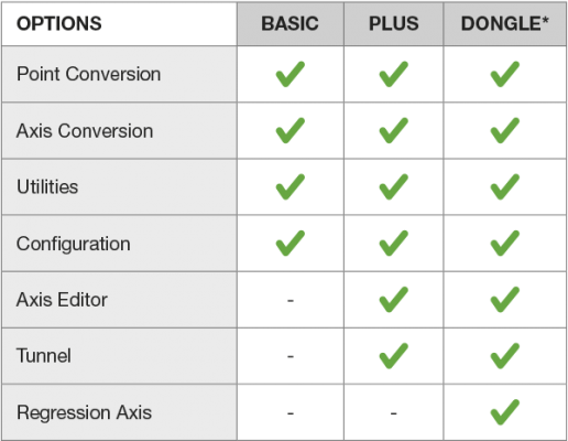
Options

The perfect complement for your survey work. Imagine a conversion software which also encompasses the basic operations that can be performed by any surveying and geodesy professional. With the new version of the Data Convert, a new range of utilities has been added, including a wide variety of all those tasks you may be performing in the course of a day’s work.
Data Convert has become become the exemplary model software when it comes to conversions. Its module for converting layout points and axes to other formats constitutes a key tool for moving your works from desk to field and from field to desk. Data Convert will give you a greater variety of transformations that include 15 different layout softwares and more than 100 file types. It also includes the possibility of not only converting the collectors of the most representative brands on the market (Trimble, Topcon, Settop, TCP, LandXML) but also of performing conversions between survey softwares, which means that, if you receive the layout of a specific program, you will be able to convert it to the system you usually work with (Istram, Clip, MDT, Inroads, Civil…).